How to Travel the Halsema Highway
Dubbed one of the world’s most dangerous road networks, the Halsema Highway makes the knees of travelers buckle. Rightly so, it snakes through craggy mountain tops, gales and dales, cliffs, and soggy valleys. The Halsema Highway is a memorable 146-kilometer journey for newcomers.
Named after its builder, American Engr. Eusebius Julius Halsema, it is a testament to resilience and sacrifice in the Gran Cordillera Central. It is a highway of life.
These are the common travel tips for traveling the Halsema Highway:
1. Plan Your Travel
Initially, the journey starts at Baguio City, Philippines, if you start from the south. The Halsema Highway traverses scenic spots and natural wonders. Making sure to map out your journey first is of utmost importance. Because, numerous stops are for the offing, like view decks, eateries, and restaurants, and scenic views along the road, readily available for your cameras. Lastly, the journey culminates at Bontoc, Mountain Province.
Restaurants and eateries dot the highway, starting at Guerilla Saddle (Km. 26). Sayangan, Atok (Km. 50) is a favorite eating stop for commuters. Moreover, restaurants at Natubleng, Buguias are the dens for vegetable dealers. Joruka Restaurant at Sinipsip, Buguias (Km. 77) has a wide area for group travelers and offers a variety of recipes on the menu. Additionally, Abatan, Buguias (Km. 90), has many eateries and restaurants, most noticeable are their steak and beef recipes.
Gasoline stations are intermittently located along the highway. The big companies stationed at La Trinidad, Atok, Buguias, Bauko, Sabangan, and Bontoc.
Importantly, planning your travel makes it an enjoyable ride.
2. Choose Your Mode of Transportation
- Private Vehicle
To maximize traveling time and flexibility, access to a car is most reliable option. Also, numerous sites and destinations are just around the corner, off the beaten path when given the freedom to navigate.
Traveling motorcycle riders need to add a layer of clothing during the cold months. Besides, riders must be wary of the sudden shift in temperature. The deep curves, and bends are a major concern too. Essentially having a ready supply of vulcanizing kits is commendable.
Bikers must be ready for the altitude and the terrain, with attention to the contours and curves of the highway. To tackle such requires extreme preparation for novices.
Hikers, trekkers, and thrill seekers can always walk the highway. Provided they equip themselves with the necessary survival gear.

- Public Transport:
Ever since, numerous vans and bus companies service the Halsema Highway. On schedule, these provincial buses leave the City. Conspicuously, they are stationed at the Slaughter Bus Terminal at Barangay Sto. Niño, Baguio City and the Dangwa Bus Station. Starting early at 6 am until 3:30 pm, these public transport daily travel the Halsema Highway.
Passenger van terminals are scattered within the central business district of the City. Notable locations are the Dangwa Station Terminal, the Enclean Van – Magsaysay Terminal, and the Rimando Van Terminal. Van fare rates are a little bit higher than bus rates, but their travel time is considerably shorter than buses
In addition, waiting passenger van terminals are within the central business district of the City. Notably, their locations are the Dangwa Station Terminal, the Enclean Van – Magsaysay Terminal, and the Rimando Van Terminal. Although, van fare rates are a little bit higher than bus rates, their travel time to reach the destination is considerably shorter than buses.
3. Travel Early
Traveling early eases problems with driving visibility. Fog blanket the Halsema Highway in the rainy season. Fog at higher elevations poses a risk and a problem. Nonetheless, the installation of solar panels on these critical stretches aids in visibility during nighttime. However, near zero visibility in the wee hours and the evening still occurs almost daily.
Traveling early is advantageous in exploring the highway if unscheduled stops are in the itinerary.
4. Check Weather Conditions
Always check the local weather forecasts. Weather conditions could change drastically considering the mountainous region. Moreover, unpredictable rain patterns persist during the wet season (July-December). Most notably, the first quarter of the year is the coldest, peaking in February.

During extreme typhoons, buses and vans do not ply their services. Services resume only when the disturbance abates. And, the green light issued by concerned national line agencies.
Constantly check advisories of the local police and disaster councils, on road conditions during inclement weather. They are plastered all over Facebook.
5. Prepare for Curvy Roads
The Halsema Highway is curvy. Definitely, traveling 146 kilometers for 5-6 hours is slow. However, traversing it at 40 kph is bliss. This is due, to the contours of the mountains it runs through, passing by mountain cliffs, ranges, and mountain tops.
Two lanes from start to finish, 4 lane roads are available but not on long stretches. Expect an influx of traffic on a fair day, the highway is the main trunk of vegetable delivery trucks from the farms to the trading post.
Lastly, be wary of deep bends and curves when driving, they are accident-prone.
6. Pack Essentials
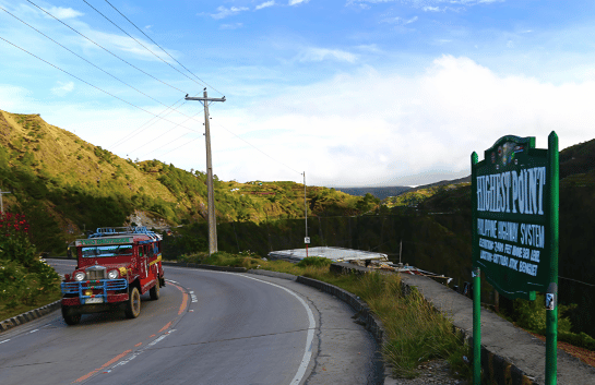
Evidently, traveling at high elevations requires warm clothing, as temperatures at times can drop significantly. Additionally, first aid kits must come in handy in case of emergencies. Preparing food, snacks, and water for the journey is an option. Having picnics as you travel is another adventure for the books. View decks, at the 2nd Highest Point View Deck (Km. 50), Amgaleygey View Deck (Km. 74), and the Mt. Kalawitan View deck (Km. 122), are welcoming for a quick break or respite.
Clean as you go. It is a way of maintaining the cleanliness of the Halsema Highway when resting on these view decks.
7. Enjoy Scenic Stops
Enjoy the scenery, taste local cuisine, immerse yourself in the local culture, view the large swathes of vegetable farms, and try the local markets.
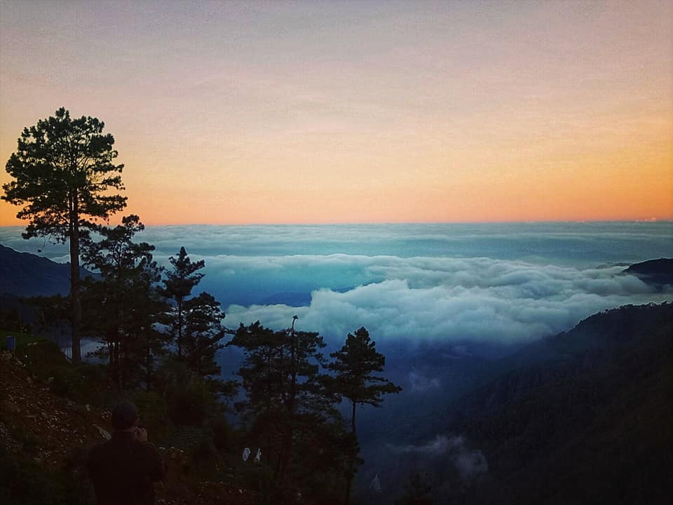
The Halsema Highway is full of scenic spots. The mountains offer a wider view of the interior Cordillera, sunrise and sunset viewing are enjoyable times.
View decks offer panoramic scenes of the vegetable terraces. The now 2nd Highest Point View Deck offers a commanding view of vegetable gardens and Mount Pulag in the distance. Moreover, the Amgaleygey View Deck offers sceneries of the large swathes of vegetable gardens of Buguias town. Evidently, it is the biggest vegetable-producing municipality in the country.

The half-tunnel portion of the highway at Atok was carved out of the rock face when the original road was washed out in 1968. It covers almost a third of the road and is a favorite shelter for motor-bikers from the rain.
Significantly, a side trip is in the offing at the Northern Blossoms Flower Farm at Sayangan, Atok. Obviously, it showcases a wide range of flower selections, most of which are endemic to the highland region.
The Halsema Highway is the backbone of the Philippines’ vegetable industry. Clearly, local markets along the highway offer a variety of highland vegetables. Alongside these local produce are lowland fruits in season. The most notable locations are the Abatan Market (Km. 90) and the Maba-ay Roadside Market (Km. 110)
Local cuisine includes pinikpikan with etag/kini-ing (dried meat), and pinuneg (local sausage). They are offered in select restaurants along the highway.
8. Respect Local Customs
Occasionally, car tires are put in place in the middle of the road at the Halsema Highway. It is a request for you to slow down, a sign of a crowded area for the meantime. Moreover, events along the highway including weddings, wakes and Thanksgiving that attract a great number of vehicles and people.

Oftentimes, vegetable trucks coming from the City are slow when laden with agricultural fertilizers. Take precautionary measures to overtake, most of the time these drivers are respectable to yield when warned of the proper signal.
9. Diversion Routes
Be mindful of diversion routes. Significantly, this is very important in extreme emergencies. The Km. 21 Labey-Ambuclao-Bokod-Kapangan-Buguias Route is in the offing when road cuts occur along Km. 21 – Km. 84 of the highway. The Salin-Balicanao Road is usable when roads are unpassable from Sinto (Km. 100) to Sadsadan. Diversion travel is necessary when there is a road cut between Maba-ay (Km. 110) and Nacagang (Km. 18). It is recommendable, to take the Maba-ay-Bauko-Nacagang Route.
10. Repair and Vulcanizing Shops:
These motor vehicle repair shops and tire tube specialists are available at major stops along the highway. Starting from Baguio City to Bontoc, they are available at major settlements. Repair shops are found at La Trinidad, Tublay, Atok, Buguias; Mt. Data, Bauko; Sadsadan and Maba-ay, Bauko; Capinitan and Nacagang, Sabangan; Dantay, Bontoc and Bontoc Proper.
Similarly, vulcanizing services are easily availed off starting Baguio City. Along the highway, they are scattered on the road. Saliently, makeshift signage advertise their services.
11. Inns and Accommodations
Inns, homestays, and hotels are readily accessible along the Halsema Highway. Likewise, numerous homestays and a campsite and staycation could be availed of at Sayangan, Atok. Moreover, hotels are located at Buguias most noticeable of which is the Garden Breeze Hotel at Barangay Bangao.

The historic Mount Data Hotel is half a kilometer away from the highway at Sinto. Secluded in a forest, surrounded by pine trees, it is ideal for a good night’s rest. Its well-kept lawns, homey kitchen, and wide parking spaces make it perfect for group incursions.
12. Medical Emergencies
You can easily ask for directions for immediate emergencies from the drivers or conductors. They are knowledgable about every health facility along the highway. At the outset, the Atok District Hospital (Km. 50) caters to medical emergencies. Further north, at Abatan, Buguias (km. 90), the health services of the Abatan Emergency Hospital together with the Abatan Lutheran Hospital are accessible. Nearer the junction road at Mabaay is the Luis Hora Regional Memorial Hospital at Abatan, Bauko. It is not along the highway, but is 8 kilometers away, veering off the road. Lastly, the Bontoc General Hospital (Km. 146) awaits at Bontoc.
13. Extreme Cases
Most especially during the rainy months and typhoon season, falling rocks, road wash outs and landslides occur. Proceed with extreme caution when encountering such. If however, the incident has no sign of abating, call for rescue. Rescue teams along the highway are ready to assist all the time.
Do not panic. Search for a safe location and wait for back up. Be in constant contact with your would be rescuers and provide clear identification and directions.
At the outset, never start the journey when inclement weather has been accounced and the typhoon signals have been raised. There is no assurance that you will enjoy a safe journey. Being stranded in the highway is the worst experience you can get. Be extremely causious.
14. Safety Precautions
Sharing travel plans with someone is paramount, when unfamiliar with the area. Keeping them updated is a way of sharing your travel adventures. Furthermore, scan Facebook and keep a list of emergency contacts of local police, local disaster offices, and fire stations along the highway. Surely, it will come in handy in dire circumstances.
Maintain a clean water supply. Many streams may slide down the mountains but the water sources are in question.
Google Maps and other transportation applications can be utilized. Some sections of the highway, however, are not fully covered by telecom networks. When having problems with directions, ask locals in the area, assuredly they are willing to help provide directions, respectfully.

Enjoy the local customs with safety in mind. Have a memorable trip, and take time to appreciate nature. A remarkable journey awaits you along the Halsema Highway. Enjoy the trip. Be happy!